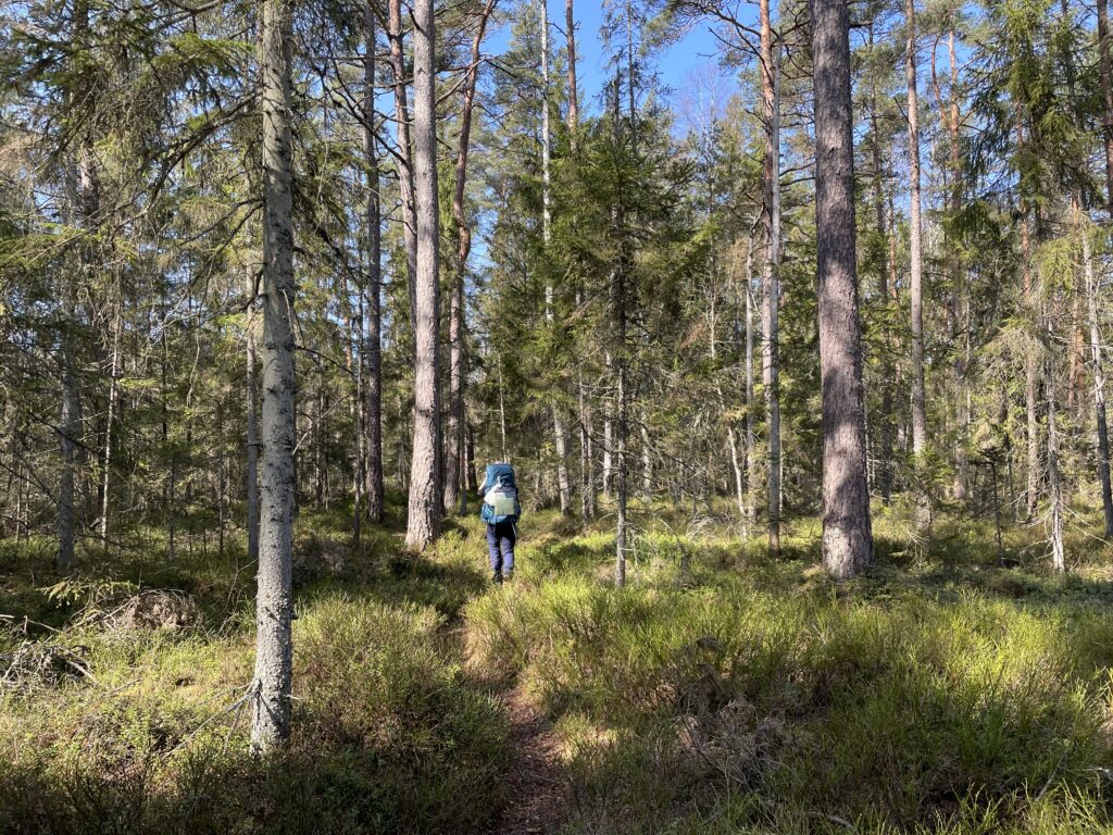
Over 9-12 days the Cathar Way (GR367) winds through 235 km in the wonderful landscape of Southern France. The name of the route originates from the nine magnificent Cathar Castle ruins it passes along the way, that sees many visitors each year due to its brutal but well known history. This makes the hike well known, yet not many people walk the full hike from Port La Nouvelle to Foix passing through beautiful mountains, idyllic vineyards and numerous ambient french mountain villages. On our hike in April we met few other hikers, but had many good (as good as possible with high school french) chats with local frenchmen very interested in two foreigners.
The path is easily to follow with many marks along the way, and both the start and end is easily reached by public transportation. It passes through many villages and can therefore easily be done with tent or in hotels/gites. This hike hike is perfect for a spring or autumn adventure where the heat is not too strong and the snow has melted when the higher mountains are covered in snow.
There are two variants of the Cathar Way: A 235km northern variant and a 253 km southern variant, disregarding visits to Cathar Castles consisting of extra 6 – 14 km of side trips. In this guide we describe the northern variant in 9 days with an alternative itinerary of 12 days for those wishing a calmer hike.
Table of Contents
ToggleCathar Way Northern Variant: The Quick Stats
Distance
235 km
Starting point
Port La Nouvelle
Total elevation
8490 m
End point
Foix
Duration
9-12 days
Accommodation
Tent or hotels/gites
Map
What to Expect
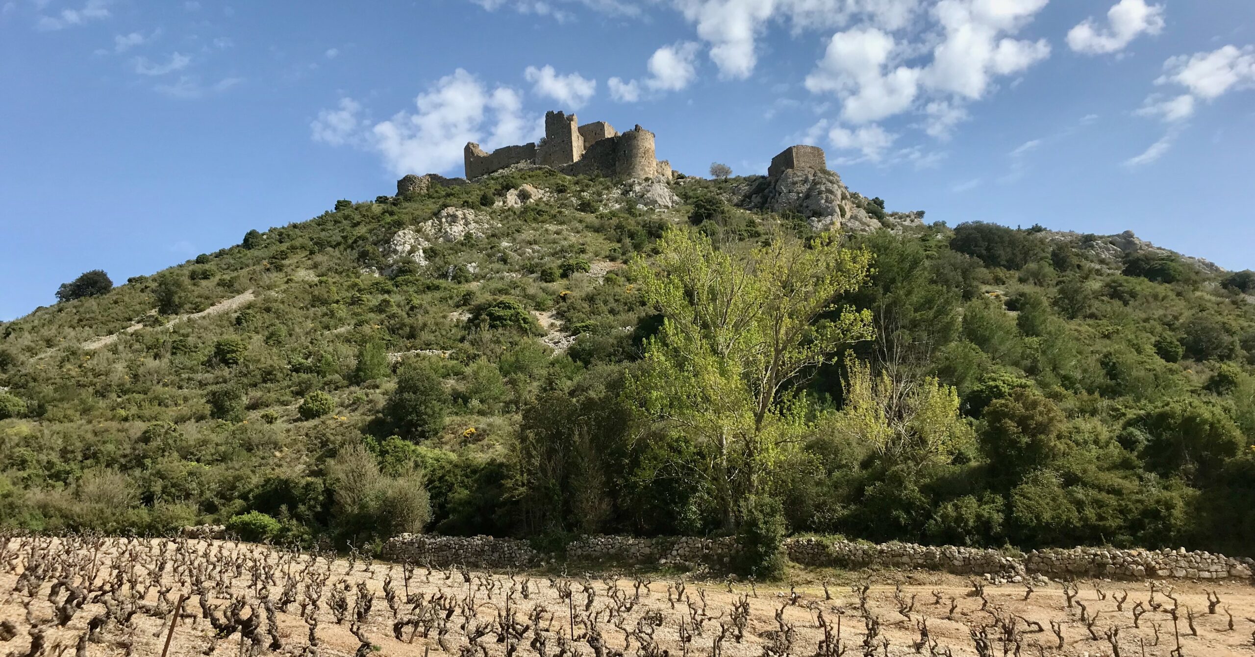
Cathar Castles
Almost every day on this trek you pass a Cathar Castle that you can visit if you wish. With their violent history the ruins attest to a brutal time in medieval France, where the catholic church waged a Crusade against the Cathars, eradicating them by 1350.
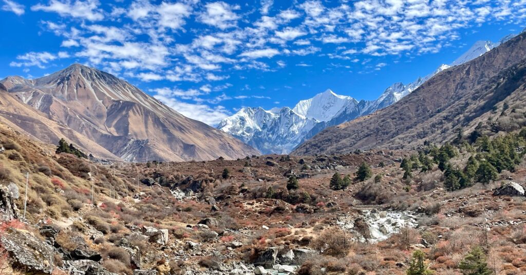
Magnificent Views to the higher Pyrenees
The path crosses several passes and climbs a few smaller summits from where you will have an amazing views to the higher Pyrenees. In Spring and Autumn these mountains are covered in snow which creates a beautiful contrast to the green and brown colours in which the trail winds.
Charming French Mountain Villages
The path enters many small charming french villages with an ambience not found anywhere in the world. Enjoy a morning coffee with the locals and visit the old churches and squares found in each of the beautiful villages.
Amazing French Cuisine
Each village has plenty of cafés and restaurants with wonderful local food and baked goods. Staying a night in a gite is a great way to try the local cuisine made with love and effort.
When to Hike
The answer to this question depends on how you’d like to spend the night and if you don’t mind a bit of snow on the way. In general March – June and September – November are the best times to do the hike, as the heat is tolerable and the trail will be free of snow. We went during Easter and had great weather almost every day without too intense heat.
While this trail is definitely doable in winter, be advised that not all gites and hotels are open during the winter months. If you go with your tent and don’t mind a bit of snow we’re sure a winter trek would be a wonderful experience.
Getting to the Trail and Back
The Cathar Way have great connections with public transport, and it doesn’t require much effort to get to the start or to get home after you finish your trek. We recommend flying or taking a train to Toulouse, and thereafter taking a train to Port La Nouvelle. From Foix there is a direct train back to Toulouse. Check the train schedules on this site.
Itineraries
Our Itinerary
We hiked the northern variant of the Cathar Way in 9 days doing approximately 26km a day on average. The numerous ascends and descends each day made for some longer days following this itinerary. In this table you can see our days as well as which end destination you can buy groceries in.
Day | Distance (km) | Time (hours) | Ascent (m) | Descent (m) | Groceries | |
|---|---|---|---|---|---|---|
1 | Port La Nouvelle ➞ Durban-Corbiéres | 27.5 | 6.5 | 655 | 566 | x |
2 | Durban-Corbiéres ➞ Tuchan | 27.5 | 7.5 | 974 | 904 | x |
3 | Tuchan ➞ Duilhac-sous-Peyrepertuse | 23 | 8 | 859 | 666 | x |
4 | Duilhac-sous-Peyrepertuse ➞ Bugarach | 27 | 8.5 | 1489 | 1383 | |
5 | Bugarach ➞ Coudons | 30 | 9 | 1396 | 992 | (Quillan) |
6 | Coudons ➞ Espezel | 30 | 8 | 735 | 702 | x |
7 | Espezel ➞ Montségur | 34 | 11 | 1173 | 1146 | |
8 | Montségur ➞ Roquefixade | 16.5 | 5 | 594 | 754 | |
9 | Roquefixade ➞ Foix | 20 | 6 | 615 | 996 | x |
If you bring a tent day 7 can be shortened if you stop in Pélail – see our day-to-day descriptions below (LINK).
A Slower Itinerary
If we had more time, we would probably have done the walk in a slower pace. If you like drinking coffee at the local cafés and visiting many of the Cathar ruins, we would recommend the following itinerary, This is also a good itinerary if you don’t bring a tent.
Day | Distance (km) | Time (hours) | Groceries | |
|---|---|---|---|---|
1 | Port La Nouvelle ➞ Durban-Corbiéres | 27.5 | 6.5 | x |
2 | Durban-Corbiéres ➞ Tuchan | 27.5 | 7.5 | x |
3 | Tuchan ➞ Cucugnan | 18 | 6 | x |
4 | Cucugnan ➞ Camps-sur-l’Agly | 20 | 6 | |
5 | Camps-sur-l’Agly ➞ Bugarach | 11.5 | 4 | |
6 | Bugarach ➞ Quillan | 23 | 6.5 | x |
7 | Quillen ➞ Puivert | 20 | 5.5 | |
8 | Puivert ➞ Espezel | 16.5 | 4.5 | x |
9 | Espezel ➞ Comus | 20 | 5.5 | |
10 | Comus ➞ Montségur | 14 | 5 | |
11 | Montségur ➞ Roquefixade | 16.5 | 5 | |
12 | Roquefixade ➞ Foix | 20 | 6 | x |
Trail Logistics
Accommodation
Tent
We brought our tent and both wild camped and slept at designated campsites. On this trek there are plenty of great spaces to put up your tent outside the small villages. In France it is generally acceptable to wild camp as long as you’re not on private ground, away from buildings, follow the leave-no-trace (LINK) principles and only stay each place for one night.
Huts/hotels
There are plenty of huts (gites) and hotels underway if you don’t want to carry a tent, and as far as we know, this is what most people do. You’ll carry a lot less gear and will be able to enjoy the trek more if you decide not to bring a tent.
As mentioned, few people do this hike, so in general you don’t have to worry about getting a room at a hut or a hotel. But we still recommend booking in advance, since some places might close if they do not have any guests on a particular day. If you hike in local holidays we always recommend booking ahead – we did the hike during Easter and most hotels were booked.
Food
You can buy food in Port La Nouvelle and many of the days on the trail – see the table above describing our itinerary. In most of the small villages they have cafés or restaurants, and if you sleep in huts you are sure to get a great breakfast and dinner from there. We recommend bringing a packed lunch for each day.
Water
There is plenty of water on the trail, so this is nothing to worry about. In almost all the villages there are taps on the town square and you will pass at least one each day. Look for signs that says L’eau potable which means drinking water in french. Of course, you can always take water from streams or lakes – be sure to treat (LINK) the water in this case.
Navigating the Trail
It’s relatively easy to navigate the trail and only basic map-reading skills are really necessary. You can download a GPX-file of the route if you buy the guidebook from Cicerone (LINK) and use an app such maps.me (LINK) with offline maps to navigate. Though, we don’t recommend relying only on your phone and thus always suggest bringing a map and compass. Maps are easy to buy and if you buy the guidebook you can also use the maps in there as a backup.
Day-to-day Tales
Day 1: Port La Nouvelle ➞ Durban-Corbiéres
Immediately after you exit Port La Nouvelle the trail ascends a slope towards a plateau filled with beautiful flowers in all colours. Continuing on the plateau the ocean disappears behind you as the trail winds down many vineyards until you reach the first small village of Roquefort-des-Corbières. This is a perfect lunch stop where you can fill your water bottles on the pretty town square if needed. The trail continues in similar landscape towards Durban-Corbières, where you will find small shops, a pizzeria as well as a water tap along the river. There are plenty of places to sleep in town, but we ascended a small hill behind the village and found a great place to pitch our tent with a wonderful view of where we came from.
Day 2: Durban-Corbiéres ➞ Tuchan
The first part of the day is an ascent to the summit of a small mountain, from where you, for the first time on this hike, get a beautiful view of the higher snow covered Pyrenees from a far. Afterwards, the trail descends through more vineyards until you reach the village Embres-et-Castelmaure. The trail continues in a forest on a small gravel road and after a while the landscape opens up and you get a great view of the Aguilar Castle and the small village of Tuchan, where the day ends. If you’re interested you can visit the castle before you walk the final stretch into Tuchan. We stayed at a nice paid campsite just south of the village.
Day 3: Tuchan ➞ Duilhac-sous-Peyrepertuse
The day starts of through plenty of vineyards besides a mountain ridge that end in a huge gorge. Passing through the gorge the trail continues alongside plenty of fields towards the small village Padern. Towering the town is a Cathar Castle, which, unfortunately, no one is allowed to visit. Exiting the town the path goes directly uphill towards Quéribus Castle, which is one of the most visited Cathar Castles on the trek. After the castle, the trail descends to a huge valley and through the cute town of Cucugnan, which has plenty of charming cafés. Continuing deeper into the valley, the path follows a paved road until Duilhac-sous-Peyrepertuse, were accommodation is available. If you’d like to sleep in your tent, follow the trail for 15 minutes more and you’ll arrive at a big flat opening which is used for paragliding. This is definitely the best place to pitch your tent on this trek, so we recommended sleeping at this wonderful location and enjoy the sunset over the mountains.
Day 4: Duilhac-sous-Peyrepertuse ➞ Bugarach
On this day is the treks first serious ascend. Out Duilhac-sous-Peyrepertuse the path ascends along the huge cliff on which Peyrepertuse Castle resides. Reaching the ridge, one is able to make a side trip to the castle. Otherwise, continue along grassy fields and start a steep ascend through scrubs and rock until you reach the top, and get a beautiful view of the higher Pyrenees. After descending through gorges and fields to Camps-sur-l’Agly the path goes over a plateau inhabited by wild horses and old ruins, before going down towards Bugarach. Here you’ll find hotels and a paid campingsite.
Day 5: Bugarach ➞ Coudons
Lorem ipsum dolor sit amet, consectetur adipiscing elit. Ut elit tellus, luctus nec ullamcorper mattis, pulvinar dapibus leo.
Day 6: Coudons ➞ Espezel
Lorem ipsum dolor sit amet, consectetur adipiscing elit. Ut elit tellus, luctus nec ullamcorper mattis, pulvinar dapibus leo.
Day 7: Espezel ➞ Montségur
Lorem ipsum dolor sit amet, consectetur adipiscing elit. Ut elit tellus, luctus nec ullamcorper mattis, pulvinar dapibus leo.
Day 8: Montségur ➞ Roquefixade
Lorem ipsum dolor sit amet, consectetur adipiscing elit. Ut elit tellus, luctus nec ullamcorper mattis, pulvinar dapibus leo.
Day 9: Roquefixade ➞ Foix
Lorem ipsum dolor sit amet, consectetur adipiscing elit. Ut elit tellus, luctus nec ullamcorper mattis, pulvinar dapibus leo.
Resources
Lorem ipsum dolor sit amet, consectetur adipiscing elit. Ut elit tellus, luctus nec ullamcorper mattis, pulvinar dapibus leo.